A warming Arctic is not just losing ice at the surface. According to a new study published in Global Biogeochemical Cycles, thawing permafrost across northern Alaska is now sending more freshwater and more long-frozen organic carbon into rivers that empty into the Beaufort Sea. Led by geoscientist Michael A. Rawlins at the University of Massachusetts Amherst, the work offers one of the clearest regional pictures yet of how a hotter climate is rewiring the Arctic’s land-to-ocean plumbing.
The findings matter far beyond Alaska. The Arctic is often described as a fast-warning system for global climate change and this study shows why. When permafrost thaws, soils that have stayed frozen for thousands of years begin to release carbon-rich material into streams and rivers. Some of that carbon is eventually converted into carbon dioxide, adding yet another push to planetary warming.
That makes the study more than a local hydrology update. It is a close look at a climate feedback loop already in motion.
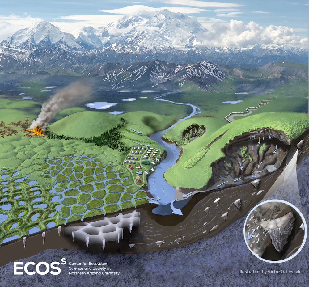
The research focused on Alaska’s North Slope, a vast region draining north into the Beaufort Sea. It is a landscape of tundra, wetlands, low-gradient river systems and perennially frozen ground. Using a high-resolution model run over 44 years, from 1980 to 2023, the team found three major changes unfolding together: runoff is increasing, dissolved organic carbon export is rising and the seasonal thaw is lasting longer into late summer and autumn.
In simple terms, the ground is staying thawed for longer, more water is moving through it and that water is carrying more ancient carbon with it.
Why Arctic rivers matter so much
Rivers entering the Arctic Ocean have an influence that is out of proportion to the size of the ocean itself. The Arctic Ocean contains only a small fraction of the world’s ocean water, yet it receives an unusually large share of global river discharge. That means even modest changes in northern rivers can alter salinity, nutrient delivery, coastal chemistry and biological productivity in a marine system that is already under pressure from warming, sea-ice loss and changing circulation.
What happens on land does not stay on land. Freshwater flowing off the tundra changes the structure of coastal waters. Organic matter carried along with that water feeds microbial activity and chemical reactions. Some of the carbon settles, some is transformed and some is emitted back into the atmosphere.
That is why river inputs are such an important piece of the Arctic climate puzzle. They connect thawing soils, inland water systems, estuaries and the ocean in one continuous process.
Until now, getting a detailed picture of that process across northern Alaska has been extremely hard. Field measurements in the region are sparse, the terrain is remote and conditions are difficult for routine monitoring. Scientists can sample individual rivers, but that does not automatically tell them what is happening across an entire coastal drainage network.
So Rawlins and colleagues turned to modeling.
A 44-year view at kilometer-scale detail
The team used the Permafrost Water Balance Model, a system developed over roughly a quarter of a century to simulate snow cover, soil temperature, water storage, runoff, active-layer behavior and related Arctic land-surface processes. In 2021, the model was expanded to include dissolved organic carbon, or DOC, allowing researchers to estimate not just how much water is moving, but how much carbon that water is carrying.
This latest study pushed the approach to a much finer scale. Instead of using broader 25-kilometer grid cells, the researchers modeled the North Slope at 1-kilometer resolution. That is a big jump in spatial detail and it matters because Arctic landscapes are highly variable. Flat, organic-rich tundra behaves differently from rocky uplands. Wet polygonal ground drains differently from better-connected stream channels. Small differences in topography and soil can strongly affect how water and carbon move.
Running a model like this is not quick. According to the researchers, each simulation required around 10 continuous days on a supercomputer at the Massachusetts Green High Performance Computing Center. The result was a day-by-day reconstruction of river flow and carbon export across a region roughly the size of Wisconsin.
That level of detail helps fill a long-standing observation gap.
The study shows that freshwater export to northern Alaska’s estuaries has increased over the study period. At the same time, dissolved organic carbon exports have also climbed. These are not isolated blips. They are part of a wider intensification of the hydrological cycle in a warming permafrost region.
What thawing permafrost actually changes
Permafrost is ground that stays frozen for at least two consecutive years, but the very top layer of soil thaws and refreezes seasonally. This surface zone is known as the active layer. In a colder climate, the active layer remains relatively shallow. As the Arctic warms, that layer deepens.
That change sounds technical, but its consequences are very physical.
A deeper active layer allows more liquid water to move through soil that used to remain locked in place. It also exposes old organic matter that has been frozen and preserved for long periods of time. Once thawed, this material can be broken down or dissolved and transported into waterways.
In other words, thaw increases both the ability of water to flow underground and the availability of carbon to be mobilized.
The new study suggests these linked changes are becoming more important on the North Slope. Snowmelt still plays a central role in Arctic river flow, especially in spring. But the authors found that late-season contributions linked to thaw and subsurface pathways are increasingly important as the thaw season extends later into the year.
That longer thaw window appears to be one of the most striking parts of the story. The researchers report that the season when the ground is actively thawing now reaches further into September and even October, several weeks later than was more typical in the past.
That matters because late-season transport can deliver freshwater and carbon at a time when coastal conditions are changing rapidly, sea ice is reduced and ecosystem responses may differ from the spring freshet period that has historically dominated Arctic runoff.
Ancient carbon is entering modern waters
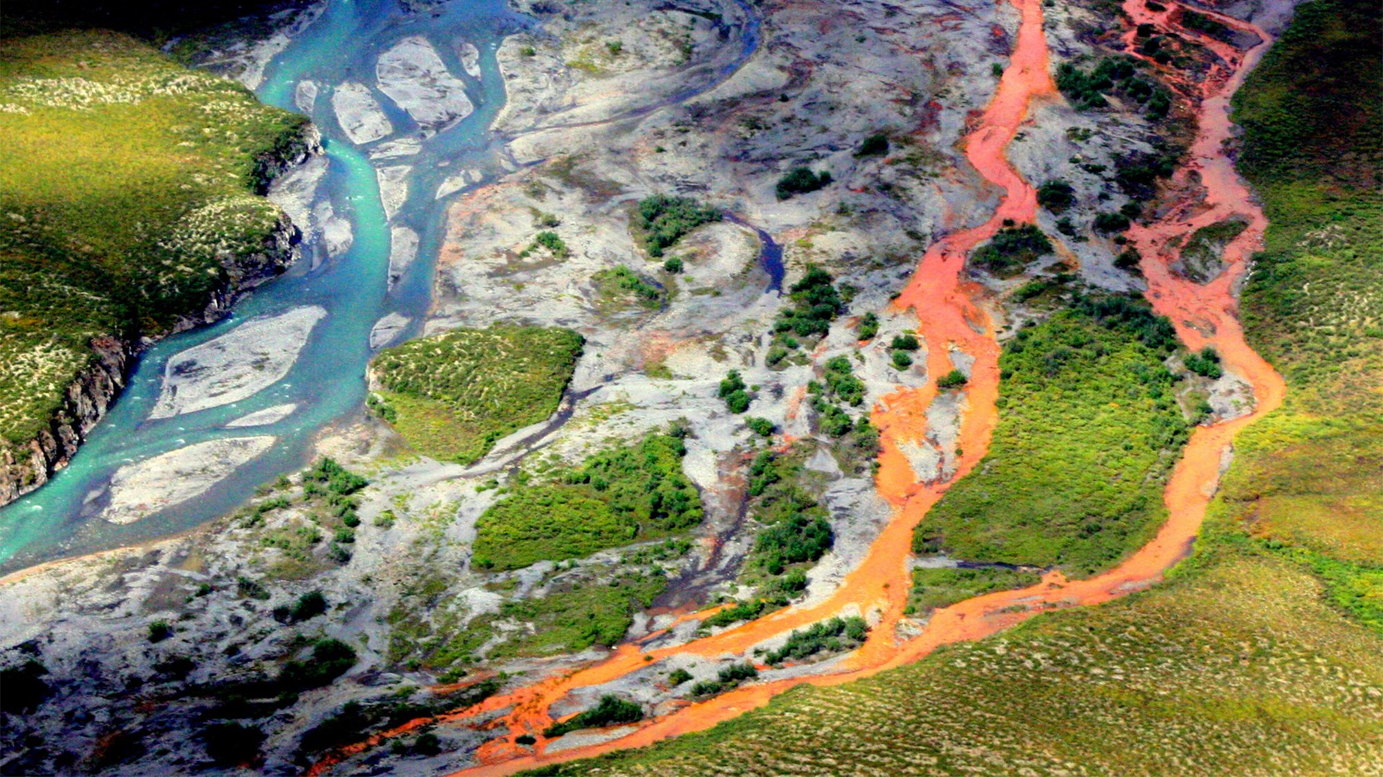
The carbon in question is not freshly produced material from this year’s plant growth alone. Much of it is ancient organic matter stored in frozen soils, especially in low-lying permafrost landscapes where organic-rich sediments have built up over thousands to tens of thousands of years.
When that carbon is released into rivers as DOC, it becomes part of the modern carbon cycle again.
This is one reason scientists are concerned about permafrost thaw as a climate amplifier. Frozen ground contains immense carbon stores. Not every gram released from soil becomes atmospheric carbon dioxide right away and some may be buried or processed slowly. But increased transport from land to water gives microbes and sunlight more opportunities to transform that carbon into greenhouse gases.
The Arctic Ocean already receives a disproportionately large share of river-borne organic carbon. Previous work has shown that large amounts of this material are converted each year into carbon dioxide. The new study adds more evidence that climate warming is likely to increase the supply pipeline feeding that process.
It is a reminder that carbon emissions are not only about smokestacks, tailpipes, or forest fires. Some are being activated by the thaw of landscapes that had, until recently, acted as long-term frozen storage.
Where the biggest increases are happening
The changes were not evenly spread across northern Alaska. One of the study’s important findings is that the largest increases in DOC export are showing up in the northwest part of the region.
That pattern seems to be tied to geography and geology.
Flatter terrain tends to hold thicker accumulations of organic-rich material, which has built up over long periods under cold, wet conditions. When these soils thaw, there is simply more carbon available to be dissolved and carried away. By contrast, more mountainous eastern areas often have rockier, sandier ground with less organic material to mobilize.
This regional contrast is useful because it shows that not all thawing permafrost landscapes will respond in the same way. Warming may be broad, but carbon release depends on what is in the ground, how water moves through it and how connected those soils are to streams and estuaries.
That also means future projections cannot rely on temperature alone. The landscape itself matters.
What this means for the Beaufort Sea coast
Once freshwater and DOC reach coastal lagoons and estuaries, the story shifts from land hydrology to ecosystem response.
More freshwater can alter salinity patterns, which affects the layering of the water column and the habitat conditions experienced by fish, plankton and benthic organisms. More organic carbon can fuel microbial respiration, changing oxygen demand and carbon dioxide production. It can also interact with nutrient cycles and light penetration, with ripple effects through food webs.
The Beaufort coast is a mosaic of estuaries, lagoons, barrier islands and shallow nearshore waters. These are biologically important systems and culturally important landscapes. For researchers and resource managers, knowing how much water and carbon is arriving and when, is increasingly valuable.
The study’s model outputs are expected to support broader efforts, including projects examining Beaufort Lagoon ecosystems and the exchange of materials between rivers, estuaries and coastal seas. That may sound specialized, but it gets at a basic question: what exactly is flowing into these northern waters as the climate changes?
The answer is becoming clearer and more concerning.
The challenge of measuring a vast, changing Arctic
One reason this work stands out is that it addresses a stubborn scientific blind spot. Northern Alaska is huge, difficult to access and expensive to monitor intensively. River sampling stations are limited. Seasonal observations can miss important events. And the places where thaw-driven change is fastest are not always the places with the best long-term records.
Models are not perfect substitutes for direct measurement, but in regions like this they are often essential tools for stitching together what scattered observations cannot provide on their own. A well-tested process model can reveal patterns over large areas and long periods, helping scientists identify hotspots, seasonal timing shifts and long-term trends that might otherwise stay hidden.
That said, the work also points to the need for more on-the-ground validation. Better river chemistry data, soil carbon mapping, groundwater observations and estuarine monitoring would all improve confidence in future assessments. The Arctic is changing fast enough that old assumptions about freeze-thaw timing, flow pathways and coastal inputs may no longer hold.
The study makes that especially clear in its late-season signal. If thaw now commonly extends into early autumn, then monitoring strategies built around spring melt alone may miss an increasing share of carbon transport.
A feedback loop that is difficult to ignore
The broader climate implication is unsettlingly familiar: warming triggers thaw, thaw releases old carbon and that carbon can contribute to more warming.
Feedback loops like this do not always unfold in dramatic single leaps. Often they build through connected changes in timing, storage and transport. The active layer deepens a little more. Groundwater contributes a little more flow. Streams carry a little more dissolved carbon. Estuaries process a little more of it into carbon dioxide.
Over time, those “little more” changes add up.
The study does not suggest that every unit of ancient carbon flushed from permafrost immediately becomes atmospheric greenhouse gas. The carbon cycle is more complicated than that. Some material may be buried in sediments. Some may be exported further offshore. Some may persist in dissolved form for a while. But the direction of change is important: the frozen reservoir is becoming more connected to active water pathways.
That means the Arctic’s role in the global carbon budget is becoming even more dynamic and potentially more unstable.
Why this matters beyond the Arctic
It can be tempting to see permafrost thaw as a distant problem, unfolding in sparsely populated places far from everyday life. But the climate system does not work in neat geographic boxes. Carbon released from thawing northern soils affects the same atmosphere that shapes heat waves, storms, droughts, crop conditions and sea-level stress elsewhere.
There is also a wider lesson in the study’s methods. Complex environmental change often happens at interfaces: land and water, frozen and thawed, inland and coastal, atmosphere and soil. Understanding those transitions requires long-term data, strong models and enough resolution to see what coarse averages smooth away.
That is exactly what this work tries to provide for one of the fastest-changing regions on Earth.
The authors describe it as part of a larger need for land-to-ocean connection studies and that seems hard to argue with. If scientists want to fully understand how the carbon cycle is responding to warming, they need to know not just how much carbon is stored in frozen ground, but how much is escaping, where it is going and what happens after it gets there.
For now, the message from northern Alaska is fairly direct. The Arctic’s frozen ground is thawing longer and deeper. Rivers are carrying more water. That water is picking up more ancient carbon. And the consequences are moving downstream.
Reference: Michael A. Rawlins, Craig T. Connolly and James W. McClelland, “Hydrological Cycle Intensification and Permafrost Thaw Drive Increased Freshwater and Organic Carbon Inputs to Northern Alaska Estuaries,” Global Biogeochemical Cycles (2026).