A new study published in Global Biogeochemical Cycles shows that northern Alaska is sending more freshwater and more long-frozen organic carbon into the sea as permafrost thaws and the warm season stretches later into the year. Led by geoscientist Michael A. Rawlins at the University of Massachusetts Amherst, the work gives one of the clearest region-wide pictures yet of how thawing ground is changing Arctic rivers, estuaries and the broader carbon cycle.
The finding matters far beyond Alaska. Arctic rivers do not just drain remote landscapes. They connect frozen soils, coastal waters, sea ice and the atmosphere. When ancient carbon that has been locked underground for thousands of years is thawed, dissolved and carried into rivers, some of it can ultimately be converted into carbon dioxide. That turns a once-stable carbon store into a fresh climate source.
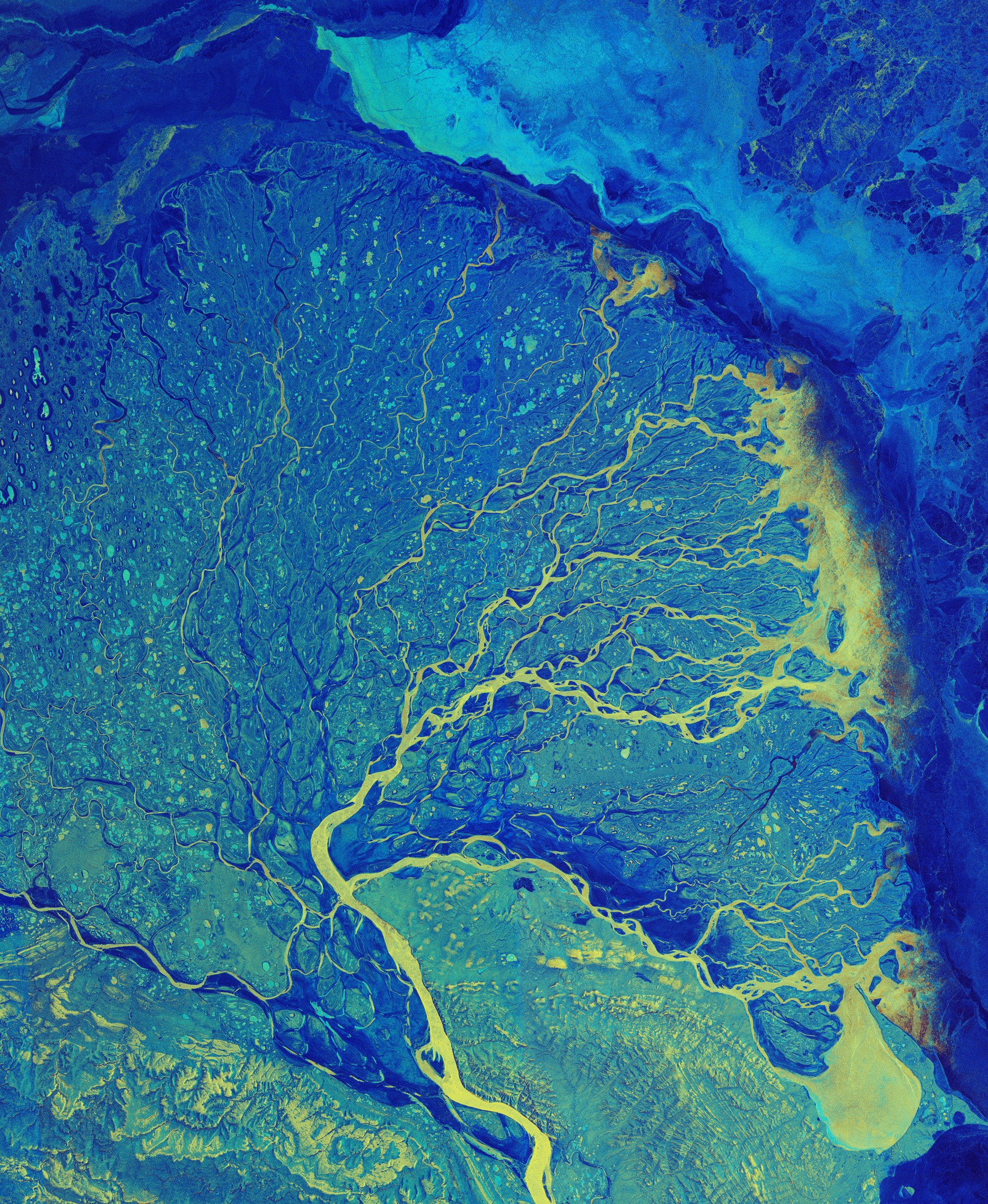
The new analysis focuses on Alaska’s North Slope, a vast region where hundreds of streams and rivers drain north into the Beaufort Sea. To understand what has changed, Rawlins and colleagues reconstructed daily hydrology and carbon export across the region from 1980 to 2023. They did this at a spatial resolution of 1 kilometer, far finer than in most earlier Arctic-wide studies.
The result is a detailed picture of a landscape in transition. River runoff is increasing. Subsurface water flow is becoming more important. The seasonal thaw now reaches later into late summer and fall. And as the active layer deepens, more dissolved organic carbon, or DOC, is being flushed out of soils that were once safely frozen.
Why the Arctic’s rivers matter so much
The Arctic can seem distant, but its rivers punch far above their weight in the Earth system. Together, Arctic rivers deliver roughly 11% of the world’s river water into an ocean that holds only about 1% of global ocean volume. That imbalance means the Arctic Ocean is unusually sensitive to what happens upstream on land.
Freshwater influences salinity, circulation, sea ice formation, nutrient transport and the productivity of coastal ecosystems. Organic matter carried by rivers also affects water chemistry, light penetration and microbial activity. In other words, a shift in Arctic runoff is not just a hydrology story. It is a climate story, a coastal ecology story and a carbon story too.
For decades, snowmelt has been the dominant driver of Arctic river flow. Spring melt still matters enormously, but it is no longer the whole picture. As permafrost warms, more water can move through the ground instead of only over its surface. That change alters when rivers flow, what they carry and where that material ends up.
At the center of the process is the active layer, the surface soil layer that thaws each summer and freezes again in winter. In a colder climate, that layer stays relatively shallow. In a warmer one, it deepens. And when it deepens, water reaches older stores of organic matter that had been frozen out of the carbon cycle.
What the study found
The team used the Permafrost Water Balance Model, a sophisticated system refined over about 25 years, to simulate snow, soil temperatures, active-layer thickness, water movement and dissolved organic carbon export. Earlier versions of the model had already been used across huge Arctic areas, but this study sharpened the lens dramatically.
Instead of working with large 25-kilometer grid cells, the researchers simulated daily flows and coastal exports at 1-kilometer resolution across an area about the size of Wisconsin. That makes it easier to capture the strong local differences that define northern Alaska, where flat tundra plains, coastal lagoons and mountain-fed catchments can behave very differently.
The study identified several important trends:
- Runoff is increasing, meaning more freshwater is moving from land to rivers and coastal estuaries.
- Permafrost thaw is deepening the active layer, allowing more groundwater-like subsurface flow.
- Dissolved organic carbon export is rising, especially in parts of northwestern Alaska.
- The thaw season is getting longer, extending into September and even October in some areas.
- Coastal estuaries are receiving changing inputs of water and carbon that could reshape salinity and ecosystem dynamics.
Each of those changes would be important on its own. Together, they point to an Arctic hydrological system that is intensifying as the region warms. More water is moving. It is moving later in the year. And it is carrying more ancient carbon with it.
Ancient carbon is no longer staying put
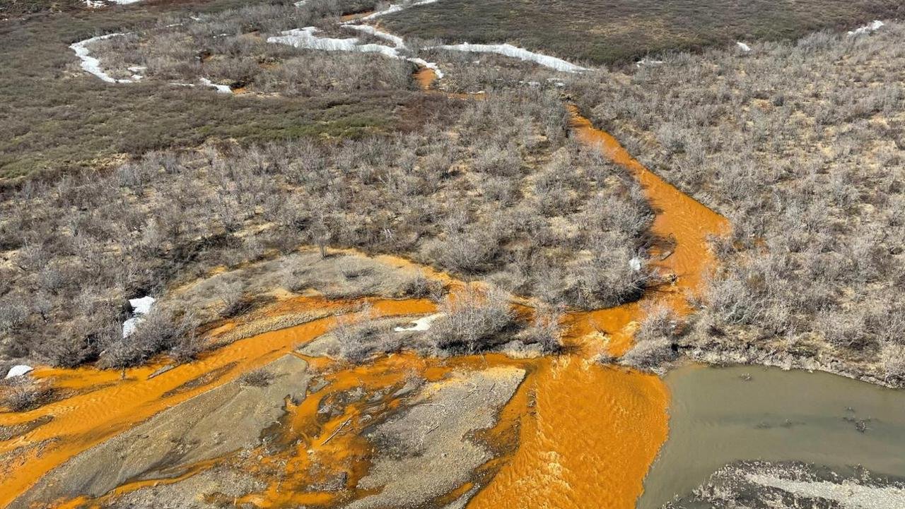
One of the most striking aspects of the study is its focus on old carbon. Permafrost soils are packed with organic matter from plants and microbes that built up over thousands and in some cases tens of thousands, of years. Because the ground stayed frozen, that material remained largely locked away, unable to decompose rapidly.
As thaw advances, that protection weakens. Water moving through the newly thawed layer dissolves some of that organic matter and transports it into streams and rivers as DOC. Once in aquatic systems, that carbon can be processed by microbes, exposed to sunlight, transformed into other compounds, or emitted back to the atmosphere as carbon dioxide.
This is why scientists are so concerned about permafrost thaw. It is not only a sign of warming. It can also amplify warming. Carbon that was stored on land becomes mobile, then reactive and eventually atmospheric.
The Arctic Ocean already receives a disproportionate amount of river-borne organic carbon compared with many other parts of the world. According to the study context, more than 275 million tons of this material are converted each year into carbon dioxide. That does not mean every molecule delivered by Alaska’s rivers will immediately become greenhouse gas, but it does show how tightly linked land thaw and atmospheric feedbacks can be.
Northwestern Alaska stands out
The changes are not uniform across the North Slope. The model suggests that the biggest increases in dissolved organic carbon export are happening in the northwest. Geography appears to be a major reason.
Flatter terrain tends to accumulate thicker organic-rich soils. Over long periods, waterlogged tundra can preserve large stores of carbon-rich material. When permafrost in those landscapes begins to thaw more deeply, there is simply more old organic matter available to be mobilized.
Farther east, the landscape becomes more mountainous. Soils there are often rockier and sandier and organic material is less concentrated. Water moving through those systems may still increase, but it tends to pick up less DOC. That regional contrast helps explain why a single Arctic-wide average can miss some of the most important local shifts.
This finer geographic detail is one of the study’s big strengths. It shows not just that change is happening, but where it may be most intense. That is vital for monitoring, ecosystem planning and future field campaigns.
The thaw season is stretching later into the year
Another standout result is the timing. Arctic warming is often discussed in terms of hotter summers or shrinking sea ice, but the calendar itself is shifting too. According to the model results, the thaw season on Alaska’s North Slope now extends further into autumn than it once did.
That matters because late-season thaw changes the balance between surface runoff and subsurface flow. It also alters how long river networks remain connected to thawed soils. If the active layer stays open longer, there is more time for water to move through carbon-rich ground and carry dissolved material toward the coast.
Late-season freshwater pulses may also affect coastal lagoons and estuaries at times of year when conditions used to be more stable. Salinity patterns can shift. Nutrient delivery can change. Food webs that depend on a predictable seasonal rhythm may be pushed in new directions.
For communities, managers and researchers working in the Beaufort coastal region, these are not abstract numbers. They point to real changes in habitat, water chemistry and ecological timing.
Why this problem has been hard to measure
It is surprisingly difficult to monitor Arctic rivers directly. The North Slope is huge, remote and logistically challenging. Many waterways have sparse sampling records and some are rarely measured at all. Harsh weather, seasonal access and the sheer number of small catchments make comprehensive field coverage almost impossible.
That is why modeling studies like this are so valuable. They do not replace direct measurements, but they help fill the enormous observational gaps between them. In this case, the model integrates weather, snow, soil, thaw depth and river transport over more than four decades, offering a coherent regional view that field sampling alone cannot yet provide.
The computational effort was substantial. According to the research team, each high-resolution simulation required 10 continuous days on a supercomputer at the Massachusetts Green High Performance Computing Center. That level of computing reflects just how complex Arctic land-water-carbon systems have become to study.
It also reflects how important they are. Better estimates of freshwater and DOC inputs can support coastal ecosystem research, improve carbon accounting and guide future monitoring programs in northern Alaska.
What happens when this carbon reaches the coast
Once freshwater and dissolved organic carbon enter estuaries along the Beaufort Sea, the story does not stop. Estuaries are chemically active mixing zones where river water meets seawater. Organic carbon can flocculate, sink, be broken down by microbes, or be transformed by light-driven reactions. Some is buried. Some is exported farther offshore. Some returns to the atmosphere.
Freshwater itself can also reshape coastal conditions by lowering salinity and strengthening stratification, especially in shallow lagoon systems. These changes can influence how nutrients circulate and how organisms from plankton to fish use the habitat.
The study’s outputs are expected to be useful to a broad range of researchers, including those working on the Beaufort Lagoon Ecosystems project. That is important, because many climate effects emerge not from one dramatic shift, but from a chain of linked changes moving from land to rivers to sea.
In the Arctic, those links are especially tight. Frozen ground controls water flow. Water flow controls carbon transport. Carbon transport affects coastal chemistry. Coastal chemistry influences ecosystem function. And all of it feeds back into the climate system.
A feedback loop the world cannot ignore
Permafrost has long been viewed as one of the planet’s major hidden carbon stores. The danger is not simply that it is melting, but that the thaw unlocks biological and chemical pathways that have been shut down for millennia. Once thawed, ancient organic matter becomes available for decomposition and export.
That creates a classic climate feedback. Warming causes permafrost thaw. Thaw releases more carbon through rivers and soils. Some of that carbon is converted into greenhouse gases. Those gases contribute to further warming, which drives more thaw.
The exact size and speed of this feedback remain uncertain and that uncertainty is one reason the new study matters. The more clearly scientists can quantify water and carbon movement from Arctic land to ocean, the better they can estimate how much additional warming these systems may produce.
The work also highlights a point that sometimes gets lost in climate discussion: not all emissions come from smokestacks, tailpipes, or industrial facilities. Some come from destabilized natural reservoirs that human-driven warming is now pushing out of balance.
What scientists will want to know next
This study opens several next questions. One is how much of the exported DOC is old versus relatively young carbon. Another is how rapidly that material is converted into carbon dioxide or methane once it enters aquatic systems. Researchers also want to understand how local landforms, including the polygonal ground created by ice wedges, affect the routing of thawwater and carbon.
There is also a need for tighter links between models and field data. More river chemistry sampling, better measurements of autumn flows and expanded coastal monitoring would all help test and refine these results. Satellite observations, airborne mapping and isotopic tracing may further sharpen the picture.
Even with those uncertainties, the broad message is already clear. Northern Alaska’s water cycle is changing. Permafrost thaw is no longer a slow background process. It is now actively reshaping when water moves, how much carbon it carries and what reaches the Arctic coast.
For a warming world, that is a warning worth paying attention to. The Arctic is not merely responding to climate change. It is increasingly becoming part of the engine that drives it forward.
Related reading
More journal reading and science coverage connected to this topic.
Artemis II Countdown Looks Better, And It’s Also A Quiet Stress Test For Space-Grade Polymers
In the latest Artemis II launch update, NASA's crewed return toward the Moon appeared to be in a much healthier place after weeks of…
Engineered Bacteria Turn PET Plastic Waste Into Levodopa in Drug-Making Proof of Concept
Researchers at the University of Edinburgh have shown that waste plastic can become the starting point for a medically important drug. In a new…

Tungsten Carbide Catalyst Offers a Tougher Route for Recycling Mixed Polyolefin Waste
A new study reports that tungsten carbide-based catalysts can hydrocrack polyolefin plastics efficiently even when the feed contains polyvinyl chloride, or PVC, a contaminant…